


Les 4 Lacs - Pic de l'Aigle

i20
User
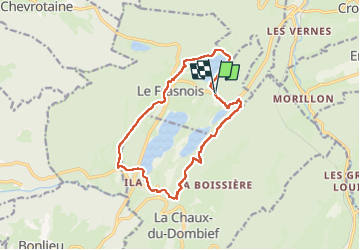

Length
13.9 km

Max alt
991 m

Uphill gradient
382 m
Km-Effort
19 km

Min alt
748 m

Downhill gradient
378 m
Boucle
Yes
Creation date :
2023-04-30 06:54:44.669
Updated on :
2023-05-01 05:39:46.098
4h21
Difficulty : Difficult

FREE GPS app for hiking
 SityTrail
IGN / Geographical institutes
SityTrail Plus
The world is yours!
About
Trail Walking of 13.9 km to be discovered at Bourgogne-Franche-Comté, Jura, Le Frasnois. This trail is proposed by i20.
Positioning
Country:
France
Region :
Bourgogne-Franche-Comté
Department/Province :
Jura
Municipality :
Le Frasnois
Location:
Unknown
Start:(Dec)
Start:(UTM)
723073 ; 5168879 (31T) N.
Comments